The Waikato region is one of the largest in Aotearoa – New Zealand, stretching from the volcanic plateau around Taupō to the lush farmland and bush of the Waikato basin, and out to the Kaimai and Pirongia ranges. With such a wide landscape, it’s no surprise the region is home to an incredible variety of hiking trails from gentle walks to challenging summit climbs.
We’ve completed about half of these tracks ourselves, while others were delayed due to weather or track closures. But they’re firmly on our list, and in the meantime we’ve gathered first-hand knowledge from friends who’ve done them. So whether you’re chasing panoramic views, sparkling waterfalls or peaceful bush walks, these are some of the best hikes in Waikato to add to your journey.
👉 Planning your trip? Grab my free campervan guide to help you get started.
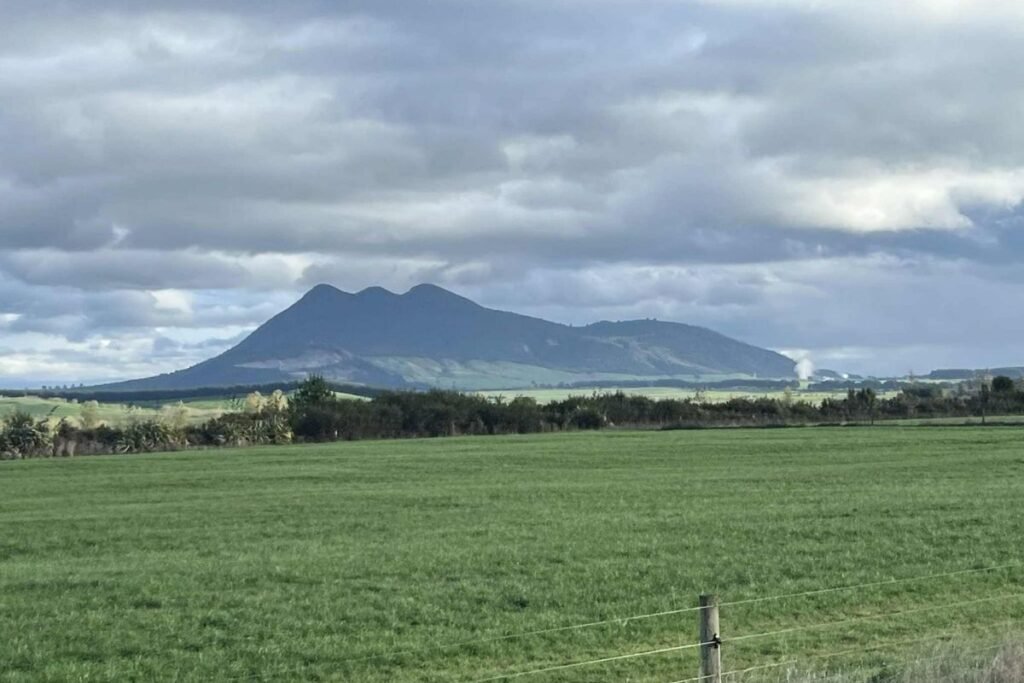
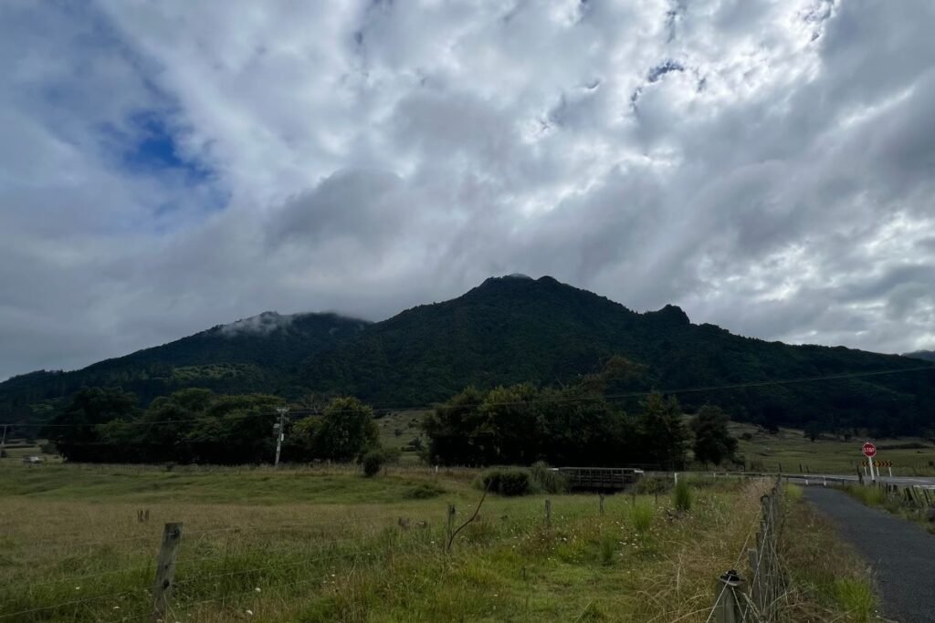
Mt Tauhara – Taupō’s Sacred Summit
Standing just outside the town of Taupō, Mt Tauhara is a sacred maunga offering one of the best short summit hikes in the central North Island. The track climbs steadily through farmland and native bush before opening out to reveal breathtaking views over Lake Taupō, Tongariro National Park, and across the Waikato region.
We actually found this track quite challenging, as we weren’t fully prepared for how it is basically up, up, up right from the carpark. There are no flat parts to rest, so it really does test your legs and fitness. But the effort is worth it, the views from the top are incredibly rewarding and standing on the summit feels like a true accomplishment.
Highlights:
- Height: 1,088 m
- Track: 2.8 km one way (allow 2–3 hours return)
- Scenery: Bush walk leading to panoramic summit views
- Why go: A sacred peak with unforgettable views over Taupō and beyond
Interesting Fact: When heading to Taupō from either Rotorua or Tūrangi, look closely at Mt Tauhara, you can see his face profile in the outline of the mountain. So handsome.
Tikitapu (Blue Lake) Track – Rotorua’s Family Favourite
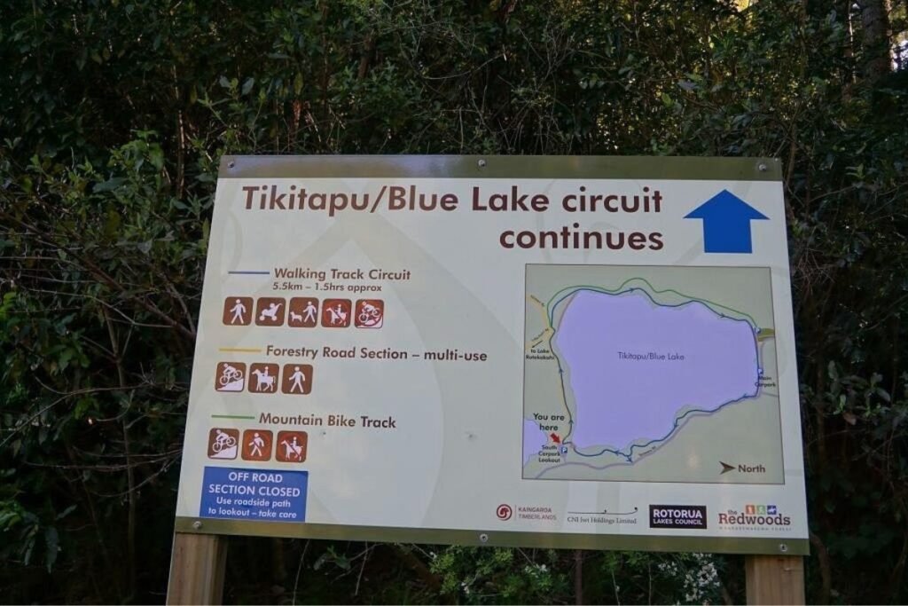
One of our favourite walks, the Tikitapu Track loops around Rotorua’s famous Blue Lake, offering an easy but rewarding trail. The path winds through native bush and along lakeside beaches, with clear views across both Blue Lake and the neighbouring Green Lake (Rotokākahi).
It’s a relaxed outing that combines scenery, swimming spots and picnic areas, making it perfect for families or anyone wanting a gentler walk with stunning lake views.
Highlights:
- Length: 5.5 km loop (1.5–2 hours)
- Scenery: Forest sections, sandy beaches and two contrasting lakes
- Why go: A family-friendly loop with plenty of spots to swim, picnic or simply enjoy the views
Interesting Fact: Tikitapu or Blue Lake, gets its name from a sacred pounamu necklace believed to have been lost in its waters by a high-born daughter of a chief.
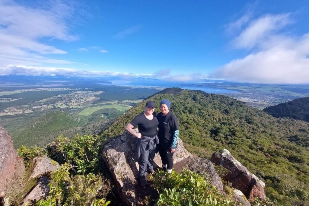
Mt Pirongia – Summit in the Sky
Rising above the Waikato plains, Mt Pirongia is the region’s highest peak at 959 m, covered in lush native forest. There are several routes up, but the most popular is the Tirohanga Track, which takes you through regenerating bush and up steep ridgelines to a summit lookout with sweeping views across the Waikato basin.
Highlights:
- Height: 959 m, the highest mountain in Waikato
- Track: Tirohanga Track around 3–4 hours one way
- Scenery: Dense native forest, ridgelines and wide open views at the top
- Facilities: DOC hut near the summit for overnight stays if you want to extend the adventure
- Why go: A challenging but rewarding climb with views stretching right across the central North Island
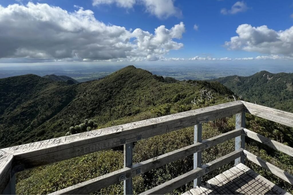
Mt Te Aroha – Peak of the Kaimai Ranges
On the edge of the Kaimai Range, Mt Te Aroha rises to 952 m, the highest peak in the range. The climb is steep and steady, winding through native bush to emerge at the summit with panoramic views over the Waikato, Bay of Plenty, and even down to Mt Ruapehu on a clear day. The nearby township of Te Aroha is known for its historic hot soda springs, the perfect place to soak after your hike.
Highlights:
- Height: 952 m, highest peak in the Kaimai Ranges
- Track: Summit Track – 3–4 hours one way
- Scenery: Bush-clad slopes opening to expansive summit views
- Extras: Natural hot soda springs in Te Aroha township for post-hike relaxation
- Why go: A tough climb with some of the best views in the Waikato region
Wairere Falls Track – Mighty North Island Waterfall
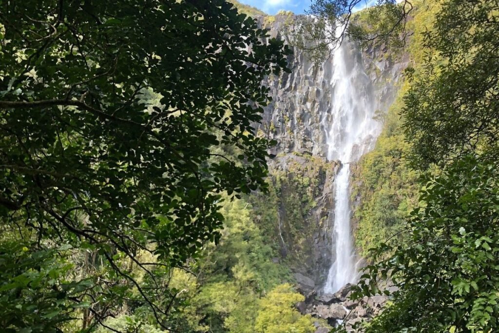
Near Matamata, the Wairere Falls Track takes you to the highest waterfall in the North Island, dropping an impressive 153 metres. The first part of the track climbs to a lookout halfway up, with sweeping views of the Waikato plains. For those keen to continue, the track carries on through forest and rocky terrain to the very top of the falls.
Highlights:
- Height: 153 m waterfall, the tallest in the North Island
- Track: 5 km return to the lookout (1.5 hours), 6 km return to the top (3–4 hours)
- Scenery: Forest tracks, rocky sections, spectacular waterfall views
- Why go: A mix of manageable hiking and dramatic scenery, worth the climb
Te Waihou Walkway – The Blue Springs
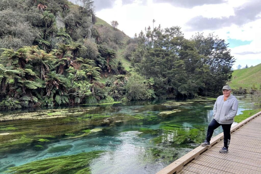
We parked at the Whites Road carpark on a quiet weekday when the crowds were almost non-existent, and it felt like we had the track to ourselves. The walk was peaceful and pretty and we found ourselves stopping often just to admire the landscape. When we reached the Blue Springs, the view was absolutely stunning, the turquoise water shimmering beneath the surface looked unreal.
Along the way, you’ll hear the rusty creak of the old waterwheel before you see it, a reminder of the area’s history. Most of the track is easy walking, though there are some inclines that would make wheelchair and pram access difficult, so it’s not advised for those users. The path follows bubbling streams through farmland and patches of native bush, with boardwalks and bridges providing perfect vantage points to take in the water’s clarity and colour.
Highlights:
- Length: 4.7 km one way (allow 1.5–2 hours return)
- Scenery: Streams, farmland, bush and the vivid Blue Springs
- Why go: A gentle, peaceful walk leading to one of Waikato’s most photographed natural wonders
👉 Ready to take the guesswork out of planning? Check out our ready-made Travel Itineraries, perfect for both campervan and self-drive adventures.
Final Thoughts on Waikato Hikes
The Waikato is full of trails that showcase just how diverse this region really is, from volcanic peaks and bush summits to sparkling waterfalls and springs. Whether you’re after a family-friendly walk or a challenging climb, there’s something here for every hiker.
Before you hit the trail, it’s always a good idea to check the DOC (Department of Conservation) website. You’ll find important updates on track conditions, weather alerts and any closures or hazards. It’s also where you can book huts or campsites on popular multi-day hikes. Checking in first helps you stay safe, pack what you need and enjoy your adventure with confidence especially in Aotearoa’s wild and changeable backcountry.
🌍 Travel Planning Resources
These are the tools we personally use and trust when planning our travels from finding a place to stay to booking activities, transport and insurance. Let your Tohu guide you — Trust the Journey and follow what feels right for you.
- ✈️Flights – Compare great deals with Trip.com then Kiwi.com for flexible, affordable options.
- 🚐 Campervans – Compare rental deals with Motorhome Republic across Aotearoa and beyond.
- 🛏️ Stays – Compare hotels on Trip.com and TripAdvisor or Booking.com.
- 🚐 Rental Cars – Compare prices and book through Airport Rentals by Motorhome Republic for trusted brands and easy airport pickup.
- 🎟️ Activities – Browse tours and experiences on Viator, Get Your Guide, or TripAdvisor
- 🚆12Go Asia – Compare and book trains, buses, and ferries across Asia in one place with 12Go.
- 🛡️ Travel Insurance – Get flexible short-term coverage with Insubuy for your next holiday.
- 🔒 Protect Your Privacy with a VPN – We recommend Surfshark VPN for secure and private browsing while travelling. It’s fast, affordable and works worldwide — perfect for public Wi-Fi at airports, cafes and hotels.
- 📱 Travel eSIM – Stay connected with Airalo
- 💼 Lounge Access – Treat yourself with Priority Pass – for UK or US
- 🎶 Events & Concerts – Book tickets worldwide through Ticketmaster.
🧭 Note: Some booking links can be a bit shy when you’re using a VPN. If one doesn’t open, try pausing your VPN or switching to a different server location or secure Wi-Fi network to get things flowing again.
He iti te mokoroa nāna i kati te kahikatea.
Even the small grub can fell the great kahikatea tree.